TOPCON HIPER V GNSS BASE AND ROVER KIT FOR SALE!!
TOPCON
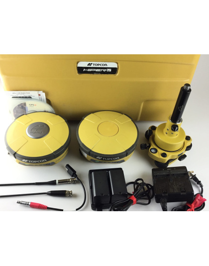
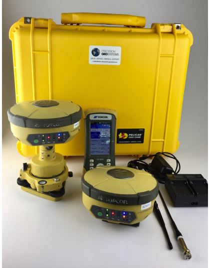
Included: 2x Topcon HiPer V Integrated Receiver Dual GD Digital UHF II 440-470 Base Rover Glonass, 4x Li-Ion Batteries, 1x CD Manual, 1x Topcon Assy, 2x Power Receiver to SAE Cable, 2x EDC113B 115VAC Power Cable for BDC 68/70 Li-Ion Battery, 1x 3M Measuring Tape, 2x UHF 450-470 Male BNC Antenna, 1x Tribrach with Optical Plummet, 1x Plug Adapter, 1x Tribrach Adapter Model -S2, 1x GPS Software CD, Carry Case.
$1,900.00
TOPCON HIPER V GNSS Base and Rover Kit
The TOPCON HIPER V GNSS Base and Rover Kit is an amazing tool used by surveyors and engineers to measure land accurately. This kit helps in understanding the exact location of places on Earth. In this article, we will explore what this kit is, how it works, and why it is so important. We will break it down into easy-to-understand sections!
What is GNSS?
GNSS stands for Global Navigation Satellite System. It is a system that uses satellites in space to help us know where we are on Earth. Just like how your phone uses GPS to help you find your way, GNSS is used for more precise measurements in various fields.
How Does GNSS Work?
GNSS works by sending signals from satellites to receivers on the ground. The receiver picks up these signals and calculates its position based on the time it took for the signals to arrive. The more satellites the receiver can connect to, the more accurate the position will be.
Introducing the TOPCON HIPER V
The TOPCON HIPER V is one of the best GNSS receivers available. It is designed to be used in different environments, whether you are in a field, on a construction site, or anywhere else. Let’s look at its features!
Key Features of the TOPCON HIPER V
- Dual-Frequency GNSS: The HIPER V can connect to both L1 and L2 frequency signals. This means it can receive signals from more satellites, which helps improve accuracy.
- Real-Time Kinematic (RTK): RTK is a method that allows surveyors to get very precise measurements in real-time. This means you can see the results instantly, which is super helpful for making quick decisions.
- Compact and Lightweight: The kit is designed to be easy to carry. It’s lightweight, so surveyors can move around without feeling weighed down.
- User-Friendly Interface: The touchscreen display is easy to use, even for beginners. You don’t need to be a tech expert to operate it!
- Long Battery Life: The battery lasts a long time, which means you can work in the field for hours without needing to recharge.
- Durable Design: The TOPCON HIPER V is built to last. It can withstand tough weather conditions, making it perfect for outdoor use.
What’s in the Kit?
The TOPCON HIPER V GNSS Base and Rover Kit includes several important components:
1. Base Station
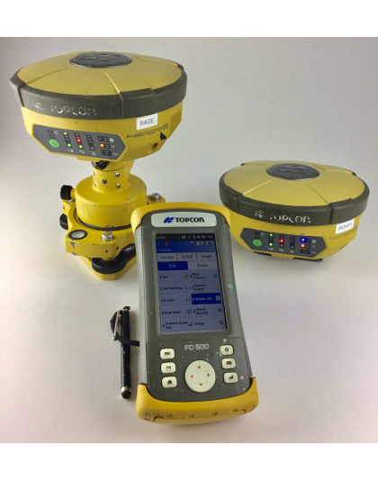
The base station is a fixed unit that stays in one place. It collects data from satellites and sends correction information to the rover unit. This helps improve the accuracy of the measurements taken by the rover.
2. Rover Unit
The rover is the mobile part of the kit. Surveyors take the rover with them into the field to collect data. It receives signals from satellites and uses the information from the base station to calculate its exact position.
3. Accessories
The kit comes with various accessories, including:
- Antennas: These help improve signal reception.
- Batteries: Extra batteries ensure you won’t run out of power while working.
- Chargers: Keep your devices charged and ready to go.
- Mounting Hardware: Helps attach the equipment securely.
Applications of the TOPCON HIPER V
The TOPCON HIPER V GNSS Base and Rover Kit is used in many different fields. Here are some of the most common applications:
1. Land Surveying
Surveyors use the HIPER V to measure land accurately. This is important for determining property boundaries, planning construction projects, and creating maps.
2. Mapping
The kit is also used for mapping. It helps create detailed maps of areas, which can be used for various purposes, including urban planning and environmental studies.
3. Agriculture
Farmers use the TOPCON HIPER V for precision farming. This means they can measure their fields accurately to make better decisions about planting, watering, and harvesting crops.
4. Construction
In construction, having accurate measurements is crucial. The HIPER V helps builders ensure that structures are built in the right place and to the correct specifications.
5. Environmental Studies
Researchers use this kit to study the environment. It helps them gather data on land use, natural resources, and changes in the landscape over time.
Why is the TOPCON HIPER V Important?
The TOPCON HIPER V GNSS Base and Rover Kit is important for several reasons:
1. Accuracy
The accuracy of the measurements provided by the HIPER V is unmatched. This is essential for any work that requires precise data, such as surveying and construction.
2. Efficiency
With real-time data, surveyors can make quick decisions. This saves time and reduces the chances of errors in their work.
3. Versatility
The kit can be used in various fields, making it a valuable tool for many professionals. Whether in agriculture, construction, or environmental research, the HIPER V is adaptable to different needs.
4. User-Friendly
Even if you are new to surveying or GNSS technology, the HIPER V is designed to be easy to use. This makes it accessible to a wider range of users.
Conclusion
In summary, the TOPCON HIPER V GNSS Base and Rover Kit is a powerful tool that helps surveyors, engineers, and farmers measure land accurately. With its advanced features, user-friendly design, and versatility, it is a must-have for anyone working in fields that require precise measurements. Whether you are mapping land, planning construction, or studying the environment, the HIPER V will help you get the job done efficiently and accurately.


